Mapping the movements of the Federal II Corps between the repulse of Barlow's division by Barringer's North Carolina cavalry brigade on June 21 and the end of II Corps' counterattacks to recover its lost guns and lines on June 22 is proving one of the most difficult tasks I have ever faced even with the help of a lifelong student of the battle such as Don Lauter, who has studied the fight for 50 years. (I'm a newcomer, having studied the struggle for only about 30.)
There are a number of maps that help one understand II Corps' position just before its rout on June 22. The first comes from the Library of Congress and depicts the Federal line on or about June 21. (I'll explain the "on or about" below.)
Library of Congress
The important part of the aforesaid map is in the lower center, where the blue line depicting the Federal position diverges and rejoins. I interpret the line on the right as the position at which II Corps arrived on the afternoon of June 21 and the line to the left as the line Pierce's and O'Brien's brigades of Gibbon's division of II Corps occupied around 3 a.m. on June 22. Hence the "on or about"
The next map is from the Official Atlas, Plate 64, No. 1. It depicts the Federal lines on Jerusalem Plank Road around August 1864. Major Duane of the Army of the Potomac's engineers drew the map for the Burnside court martial. It gives a more detailed picture of the lines than the June 21 map.
Official Atlas of the Civil War
The first important line on the map above runs from southwest to northeast and enters Jerusalem Plank Road just north of Fort Davis. To its left is the line occupied by the main bodies of Pierce's and O'Brien's brigades of Gibbon's division and the 12th New York Battery at 3 a.m. on June 22. The upper part of the line still farther to the left was held by the pickets of Pierce's and O'Brien's brigades.
The next important map bears on the disposition of Mott's II Corps division, two brigades of which were brought up regiment by regiment on the left (west) of Gibbon's division on an east-west rather than a north-south axis beginning at 4:50 a.m. on June 22. Major John Willian, the author of the map, belonged to Mott's staff and had led one of the two advancing brigades on June 16. I bought his map at auction a few years ago and have made it available to anyone who wants to study it.

Map of Maj. John Willian of Mott's Staff, Courtesy of John Horn
This map demonstrates that the line of Chaplin's and McAllister's brigades of Mott's division (later extended westward along the same axis by Fraser's brigade of Barlow's division ) lay within view of the Confederate fortifications around Petersburg--the Dimmock Line.
Finally there's map by Nathaniel Michler, Major of Engineers, Acting Chief Engineer for the Siege of Petersburg. This map shows the lines of the previous maps in a more developed state, as well as Union fortifications erected long after the fight of June 21-22.
The east-west line in the northeastern quadrant of the map puts in perspective the line of Chaplin's and McAllister's brigades of Mott's division as well as Fraser's brigade of Barlow's division. They all faced and viewed the Confederate fortifications. The problem with the Michler map is that it includes many later lines.
I didn't have the Library of Congress June 21 map when I drafted the June 22 map for my friend Hampton Newsome to polish up for my account of the fight in The Petersburg Regiment in the Civil War: A History of the 12th Virginia Infantry from John Brown's Hanging to Appomattox, 1859-1865 (Savas Beatie, 2019). Any errors are mine; nonetheless, I didn't do a bad job. (Hampton made it look a lot better than my sketch!)
Map by Hampton Newsome
Digesting the aforesaid maps along with diaries, letters, memoirs, regimentals, official reports and more than 20 helpful maps from lifelong student of the fight Don Lauter produced my following sketch of the position assumed by II Corps between 4:50 a.m. on June 22 and about 3 p.m. that day ending on the Michler map. That was when the Confederate attack led by Brig. Gen. William Mahone precipitated a rout of II Corps termed, "The Petersburg Affair," also known as "Barlow's Skedaddle." Barlow and Mahone underwent their baptisms of fire opposite one another at Seven Pines on June 1, 1862, Barlow as colonel of the 61st New York, Mahone as a brigadier general leading the 3rd Alabama, 12th Virginia and 41st Virginia; the Barlow's regiment had repulse Mahone's men at that battle.
Sketch by John Horn on Michler Map, Courtesy of Library of Congress
Up to the northwest, surrounded by his staff, Brig. Gen. Francis Channing Barlow was washing his feet at a spring. Three brigades of his division were posted on the left of Mott's front line, which was connected to O'Brien's brigade of Gibbon's division by the 1st Massachusetts Heavy Artillery. Behind the line of June 21 stood from north to south Blaisdell's and Smyth's brigades of Gibbon's division, Brewster's and Madill's brigades of Mott's division, and Miles' brigade of Barlow's division.
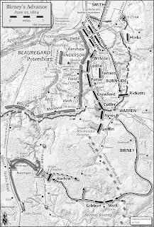
Hal Jespersen will soon transform my hen-scratching into one of his beautiful maps. An example of his work (concerning II Corps' advance under Birney on June 21) follows.
Map by Hal Jespersen
I expect around 39 of them to grace the pages of my forthcoming book on the fighting around Petersburg from June 20, 20 July 1, 1864. The text is finished except to accommodate what I learn from mapping, which so far has been fairly substantial. A conservative estimate of a publication date would be two or three years more.


No comments:
Post a Comment